
The management of a mineralization field or an exploration reserve, despite a correct understanding and realistic description of the form of in-depth deposit development, can pave the way for making the right decisions and selecting appropriate plans and contractors to improve optimal mining management and efficiency. Reserves in the future development plan of the region.
Volumetric measurement of recoverable reserves with tailings with a suitable margin from head to toe, is the most effective parameter in making these decisions and preparing mine development plans. In this regard, the application of three-dimensional simulation methods from extensive field studies that will provide scientific and practical support for the model will be presented. Results of data processing (on information with spectral, field, lithological, mineral, structural, geophysical and drilling values in three dimensions) using geostatistical methods that in addition to estimating storage parameters also based on the amount of estimation error The volume and level of trust determine the input information is the best option. At this stage, for the three-dimensional integration of all the aggregated information, a digital and processable three-dimensional static model of structural, lithological and geometric features of ore development in depth and in three dimensions of each block will be presented. According to the studies done so far, among the interpolation methods, the results obtained from the Gaussian method are more acceptable than the kriging method, which will be used in the target area in the final stage of modeling the forthcoming design. Finally, using the outputs of the optimal model, volumetric calculations will be performed and storage parameters such as the volume of waste required at each point and the amount of grade storage of each block will be determined at a specific confidence level.
Software: Gemcom-Gems; Surpac; Datamine; LeapFrog; Voxler
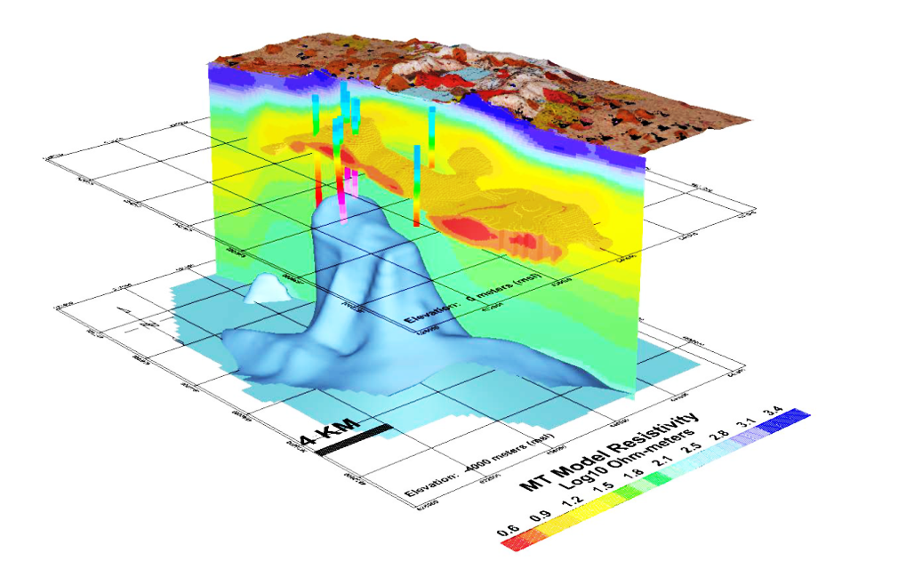
An example of a perspective map resulting from a combination of geophysical, lithological, morphological and drilling layers with a three-dimensional deposit development model